
Installation is in progress of the Portland Street neighbourhood traffic Improvements and bikeway between Queen Street and Front Street. Please see details on the Installation Notice. For details on navigating the new one-way segments, please see the new Portland Street map.
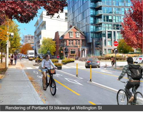
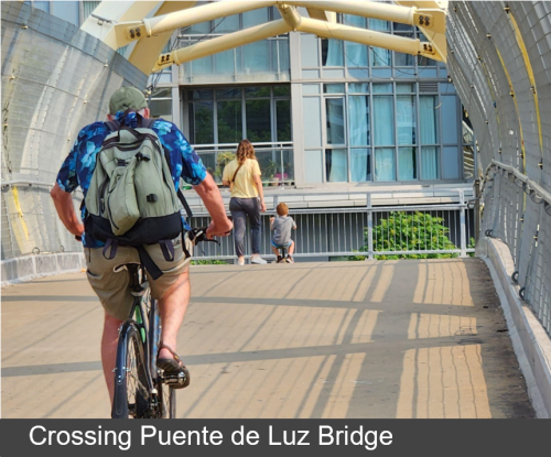
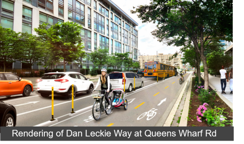
The City of Toronto has approved a new cycling route (IE12.4.) along Portland Street – across the Puente De Luz pedestrian/cycling bridge – and down Dan Leckie Way. This project is part of the Council-approved Cycling Network Plan for 2024 and will provide a safe cycling route connecting our City’s waterfront with the bustling and rapidly growing fashion district and provides traffic calming measures to reduce neighbourhood traffic infiltration.
April 2026 – Installation Notice
The portion of the Portland-Dan Leckie bikeway on Portland Street from Queen Street to Front Street, is planned for installation starting the week of April 30 2026 (weather dependent). Key changes include:
Based on public feedback, the block of Portland Street from Wellington Street to Front Street will remain two-way for motor vehicles.
In 2024, the Dan Leckie segment of the Portland-Dan Leckie project was installed as planned, but the Portland segment was deferred to accommodate the heaviest volume of construction vehicles using Portland Street for a hauling route during excavation for the King/Bathurst Ontario Line Station. This heaviest hauling period was completed in December 2025, and the Portland bikeway began installation in spring 2026.
The City has been closely monitoring the traffic impacts of several recent development projects in the area. Most recently, the development of The Well, expected to be a generator of 22,000 trips per day is now fully operational and has not impacted local motor vehicle volumes on Wellington or Portland Street. Transit and transportation option investments including RapidTO Bathurst, the Ontario Line and safe and intuitive cycling infrastructure are an integral part of transportation planning to sustainably accommodate growing populations.
The Portland street bikeway and traffic improvements is part of an integrated transportation plan to minimize neighbourhood traffic infiltration. The introduction of one-way streets and the diverter at Portland and Wellington make Portland a local-traffic only route which will no longer act as a cut-through route between Front Street to Queen Street. Preliminary findings show that RapidTO Bathurst has not substantially increased volumes on neighbourhood streets, and work continues to address adjustments at intersections to improve traffic flow along Bathurst Street. The Portland bikeway and new neighbourhood traffic patterns will be well established before the 2027 King Street streetcar track work commences.
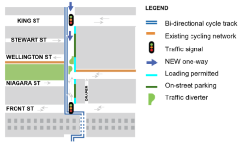
Community members have requested some degree of traffic management at the off-set intersection of Portland Street and Wellington Street for several years. Given the heavy pedestrian volumes at this intersection connecting to Victoria Memorial Square, and cycling volumes expected to increase with the introduction of the Portland bikeway, as well as existing issues around safety, confusion and traffic volumes on neighbourhood streets, the diverter was proposed to address all of these issues by minimizing the number of motor vehicle movements at this intersection and reducing non-local traffic through the neighbourhood. Emergency vehicles will still be able to traverse through the diverter. The diverter is made of modular materials including planters and flexible signage, and will be closely monitored should any adjustments be required.

The project area extends along Portland Street from Queen Street to Front Street, across the Puente de Luz Bridge, and along Dan Leckie Way from Queens Wharf Road to the Martin Goodman Trail.
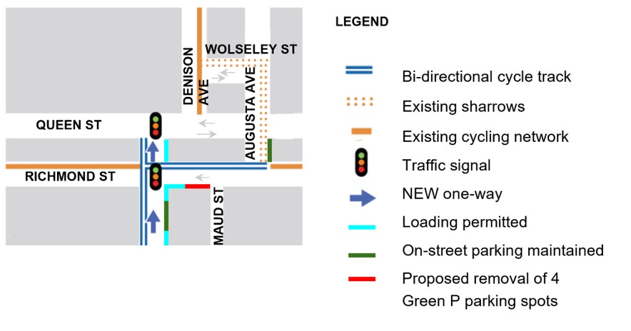
Based on public feedback, the Northbound one-way segment of Portland Street will extend from Adelaide Street to Queen Street.
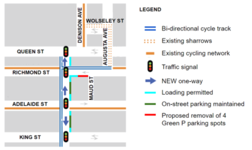

Based on public feedback, the block of Portland Street from Niagara Street to Front Street will remain two-way circulation for motor vehicles
The bridge will connect the north and south segments of the Portland – Dan Leckie bikeway. Cyclists must yield to pedestrians while crossing the bridge.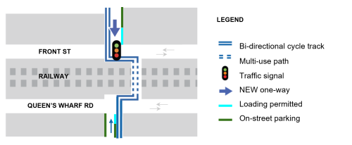

North of Fort York Boulevard
South of Fort York Boulevard

Please note that the the formal consultation period is now closed, materials, information and reports on past consultation are available in the links below.
Please email michael.carroll@toronto.ca to be added to the project list and to stay informed.